| In today's satellite era there has been a shift away
from ground based conventional measuring systems to remote
sensing from Earth orbiting spacecraft. National priorities
emphasize the use of high technology space systems partly
because measurements from ground based locations have
been labor-intensive and expensive. However, high satellite
launch costs necessitate higher satellite reliability,
which increases the required investment in satellite systems.
After forty years, a new, more affordable strategy is
being considered.
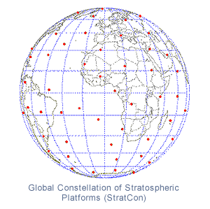
An inexpensive and long-lived balloon network is now
possible due to the advances in electronics, communications,
and balloon technologies. Together, the inherent difficulty
of making remote measurements from satellites, a new
interest in simultaneous global measurements, and the
high cost of space operations argue for a reevaluation
of the current reliance on satellites for many global
environmental measurements.
During the first year of Phase II, Global Aerospace
Corporation developed a simulation capability to evaluate
new constellation geometries related to hurricane monitoring
and tracking. These new simulations indicate that with
minimal balloon path modification, we can track and
observe a hurricane. In addition, working with Princeton
University, GAC has developed a new framework for constellation
geometry management that utilizes organizational concepts
from behavior of living creatures (flocks, schools,
and pods).
In the upcoming second year of Phase II, Global Aerospace
Corporation will continue to help scientists and researchers
identify applications for global balloon constellations.
GAC is also developing balloon and payload system concepts,
designing advanced balloon flight path control systems,
researching geometry management for global constellations,
and investigating international overflight issues.
For more information on global balloon networks, click
here |